ICYMI
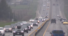
Spring is officially in the air as of Tuesday night, but that isn't stopping Mother Nature from sending one final wallop of snow and frigid air through London and the surrounding area.
According to CTV News London’s Meteorologist Julie Atchison, a winter weather travel advisory is in effect for parts of Bruce County, Grey County and the Bruce Peninsula as the next wave of snowfall makes its way through midwestern Ontario.
"Some areas can expect 10 to 15 cm of snow on Tuesday," said Atchison. "South of that, snowfall amounts are trace to a couple of cm towards London, Elgin County just some flurries, Oxford will see trace amounts of snow — but in through Central Huron and Perth County, and southern Grey and Bruce, you could see 5-10 [cm]."
Despite spring officially arriving on Tuesday at 11:06 p.m., the region will see a final burst of winter before the season ends with wind chill values of – 10 expected in the morning, followed by a daytime high of 3 C.
Atchison said daytime highs will be below normal over the next several days, hovering at approximately 0 C.
The normal for this time of year is 6 C with the low around -3 C.
Tuesday: Flurries ending near noon then cloudy with 30 per cent chance of flurries. Wind southwest 30 km/h gusting to 50 km/h. High 3 C. Wind chill – 10 in the morning. UV index 3 or moderate.
Wednesday: Cloudy with 60 per cent chance of snow. High 0 C.
Thursday: Sunny. High – 1 C.
Friday: Cloudy with 60 per cent chance of flurries. High 0 C.
Saturday: A mix of sun and cloud. High 1 C.
Sunday: A mix of sun and cloud. High 1 C.

State-sponsored actors targeted security devices used by governments around the world, according to technology firm Cisco Systems, which said the network devices are coveted intrusion points by spies.
It's one thing to say you like Taylor Swift and her music, but don't blame CNN's AJ Willingham's when she says she just 'oesn't get' the global phenomenom.
Although it's still unclear how much damage Robert F. Kennedy Jr.'s candidacy can do to either Joe Biden or Donald Trump this election, Washington political columnist Eric Ham says what is clear is both sides recognize the potential threat.
Students protesting the Israel-Hamas war at at universities across U.S., some of whom have clashed with police in riot gear, dug in Saturday and vowed to keep their demonstrations going, while several school faculties condemned university presidents who have called in law enforcement to remove protesters.
A Sherwood Park family says their new house is uninhabitable. The McNaughton's say they were forced to leave the house after living there for only a week because contaminants inside made it difficult to breathe.
More than 115 people who viewed the solar eclipse in Ontario earlier this month experienced eye damage after the event, according to eye doctors in the province.
Hamas said Saturday it was reviewing a new Israeli proposal for a ceasefire in Gaza, as Egypt intensified efforts to broker a deal to end the months-long war and stave off a possible Israeli ground offensive into the southern Gaza city of Rafah.
Ottawa has plans to finally stop blocking Canadian development aid to Afghanistan this year.
Harvey Weinstein will appear in a New York City court next week, the first step in potentially retrying the film mogul after his 2020 rape conviction was overturned.
The Shopping Trends team is independent of the journalists at CTV News. We may earn a commission when you use our links to shop. Read about us.