Rollercoaster spring weather expected in the Forest City
The stretch of summer-like weather with both sunshine and record-breaking warmth has come to an abrupt end.
Unseasonably cool air has settled back into southern Ontario with showers and lake-effect rain.
A deep upper low is slowly moving overhead and will continue to spin cool, wet weather over the Great Lakes into Tuesday.
The chance for light rainfall will linger with a few flakes of snow mixing in, and temperatures will average close to 10 C below normal Tuesday afternoon.
High pressure will build back into the area Wednesday with sunshine, and a brief one-day warm up will arrive on Thursday.
The spring temperature ride continues, however, as another cold front will cross Friday with a blast of chilly weather expected for the weekend.
Here’s a look at London’s forecast for the rest of the week:
Tuesday: Cloudy. 30 percent chance of flurries changing to 30 per cent chance of rain showers or flurries near noon. Wind southwest at 30 km/h. High of 3 C.
Wednesday: Sunny. High of 12 C.
Thursday: A mix of sun and cloud with a 30 per cent chance of showers. High of 22 C.
Friday: Cloudy with a 60 per cent chance of showers. High of 15 C.
Saturday: Cloudy with a 60 per cent chance of showers. High of 9 C.
Sunday: Cloudy with a 60 per cent chance of showers. High of 8 C.


CTVNews.ca Top Stories
BREAKING
BREAKING Police investigating shooting outside of Drake's Bridle Path mansion: source
Toronto police are investigating a shooting that took place outside of Drake’s Bridle Path mansion early Tuesday morning, a source tells CP24.
Canadian cadets rock mullets and place second at U.S. military competition
Sporting mullets, Canadian Armed Forces officer cadets placed second in an annual military skills competition in the U.S.
'It looked so legit': Ontario man pays $7,700 for luxury villa found on Booking.com, but the listing was fake
An Ontario man says he paid more than $7,700 for a luxury villa he found on a popular travel website -- but the listing was fake.
Your body needs these three forms of movement every week
Movement is movement, right? Not exactly. Here’s what your body is looking for in addition to your morning walk or yoga session, according to experts.
The Met Gala was in full bloom with Zendaya, Jennifer Lopez, Mindy Kaling among the standout stars
The Met Gala and its fashionista A-listers on Monday included Jennifer Lopez, Zendaya and a parade of others in a swirl of flora and fauna looks on a green-tinged carpet lined by live foliage.
Quebec to limit sperm donations per donor after 3 men from same family father hundreds of children
Quebec is looking at tightening the regulations around sperm donation in the province following the release of a documentary that revealed three men from the same family fathered hundreds of children.
There's actually no such thing as vegetables. Here's why you should eat them anyway
The rumours are true: Vegetables aren't real — that is, in botany, anyway. While the term fruit is recognized botanically as anything that contains a seed or seeds, vegetable is actually a broad umbrella term.
Noelia Voigt resigns as Miss USA, citing her mental health
Noelia Voigt, who was crowned Miss USA in November 2023, has announced she is resigning from her role, saying the decision is in the best interest of her mental health.
Highlights from the 2024 Met Gala exhibit: Sleeping Beauty would wake up for these gowns
Sure, she was a royal princess and all. But there’s no way Sleeping Beauty — either before or after her nap — ever had quite the fabulous wardrobe that’s been assembled at the Metropolitan Museum of Art.
Shopping Trends
The Shopping Trends team is independent of the journalists at CTV News. We may earn a commission when you use our links to shop. Read about us.


Kitchener
-
 Breaking News
Breaking News Police investigating report of shots fired into Kitchener residential building
Police are currently responding to a report of gunshots in the area of Harold Avenue and Jean Avenue in Kitchener.
-
OPP urge safety as another wrong-way driver spotted on Highway 401
There have been two fatal wrong-way collisions on Highway 401 in the last week, and on Sunday, another driver was seen travelling in the opposite direction near Cambridge, Ont.
-
Stratford resident banned from city property and contacting staff
A couple of Stratford residents claim they have been banned from attending any city owned properties or from speaking with any city staff for three months.
Windsor
-

Wanted offender unlawfully at large for 9 years captured by ROPE Squad
The Repeat Offender Parole Enforcement (ROPE) Squad has apprehended a wanted offender who went unlawfully at large nine years ago.
-
April crime stats released by Windsor police
Some areas saw a decrease while crime against people were up slightly compared to a year a go.
-
BREAKING
BREAKING Police investigating shooting outside of Drake's Bridle Path mansion: source
Toronto police are investigating a shooting that took place outside of Drake’s Bridle Path mansion early Tuesday morning, a source tells CP24.
Barrie
-

Museum inspires change-makers to contribute to Canada's net-zero goal
A museum in Collingwood, Ont., is calling on all change-makers to explore the science of climate change and help Canada reach its net-zero greenhouse gas emissions goal.
-
Barrie looking for feedback on culture plan and art strategy
City of Barrie wants the public's help to determine a new cultural and art strategy.
-
Wasaga Beach prepares for the worst with preparedness training
16 groups of emergency personnel train for disasters in Wasaga Beach.
Northern Ontario
-
BREAKING
BREAKING Police investigating shooting outside of Drake's Bridle Path mansion: source
Toronto police are investigating a shooting that took place outside of Drake’s Bridle Path mansion early Tuesday morning, a source tells CP24.
-
'It looked so legit': Ontario man pays $7,700 for luxury villa found on Booking.com, but the listing was fake
An Ontario man says he paid more than $7,700 for a luxury villa he found on a popular travel website -- but the listing was fake.
-
BREAKING
BREAKING Man taken to Timmins hospital with gunshot wound after shooting on Sixth Avenue
People in Timmins are waking up to a heavy police presence and road closures in the area of Sixth Avenue and Pine Street on Tuesday morning.
Ottawa
-
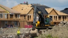
Homebuilders issue warning about proposed $12,000 hike in Ottawa development charges
The Greater Ottawa Home Builders Association warns a $12,000 increase in development charges on new homes will create an unexpected cost for homebuyers planning to buy a new home in Ottawa this year.
-
Weather alerts becoming an added barrier to getting children and youth active, ParticipACTION Report Card says
An increase in weather alerts across the country and the impacts of a changing climate are becoming an added barrier to getting children and youth active in Canada, according to a new report.
-
East-end Ottawa family dealing with massive rat infestation
Residents in Ottawa’s Elmridge Gardens complex are dealing with a rat infestation that just won’t go away. Now, after doing everything they can to try to fix the issue, they are pleading with the city to step in and help.
Toronto
-
BREAKING
BREAKING Police investigating shooting outside of Drake's Bridle Path mansion: source
Toronto police are investigating a shooting that took place outside of Drake’s Bridle Path mansion early Tuesday morning, a source tells CP24.
-
'It looked so legit': Ontario man pays $7,700 for luxury villa found on Booking.com, but the listing was fake
An Ontario man says he paid more than $7,700 for a luxury villa he found on a popular travel website -- but the listing was fake.
-
Police investigate deadly shooting in Toronto's Oakwood Village neighbourhood
One man is dead and a woman suffered minor injuries after a shooting in the city’s Oakwood Village neighbourhood early Tuesday morning.
Montreal
-

Quebec to limit sperm donations per donor after 3 men from same family father hundreds of children
Quebec is looking at tightening the regulations around sperm donation in the province following the release of a documentary that revealed three men from the same family fathered hundreds of children.
-
BREAKING
BREAKING Police investigating shooting outside of Drake's Bridle Path mansion: source
Toronto police are investigating a shooting that took place outside of Drake’s Bridle Path mansion early Tuesday morning, a source tells CP24.
-
Montreal bakers putting on a bake sale for children in Gaza
A group of Montreal bakers is getting together to put on a bake sale to raise money for children in Gaza.
Atlantic
-

N.S. crews searching for missing man in capsized boat
The Joint Rescue Coordination Centre is searching for a man missing from a capsized recreational boat in Annapolis County, N.S.
-
Weak oversight of N.S. youth homes increases risk of improper child care: auditor
Nova Scotia's auditor general says vulnerable children are at risk of being improperly cared for because of weak oversight within the province's temporary care and youth home network.
-
Nova Scotia man dies after truck, motorcycle collide in Union Corner
A 20-year-old man has died following a collision between a pickup truck and motorcycle in Union Corner, N.S., on Sunday.
Winnipeg
-

Group boycotting Loblaws over rising food prices
Fed up with the ever rising price of food, an online movement has sprung up to fight back in the form of a boycott.
-
Winnipeg man admits to killing four women, argues he's not criminally responsible
Defence lawyers of Jeremy Skibicki have admitted in court the accused killed four Indigenous women, but argues he is not criminally responsible for the deaths by way of mental disorder – this latest development has triggered a judge-alone trial rather than a jury trial.
-
Manitoba to use tobacco suit windfall to fight cancer: Premier
A windfall from a lawsuit against big tobacco could see a major expansion to help cancer patients.
Calgary
-
Hit-and-run at Calgary business linked to break-and-enter, police say
Calgary Police are investigating an attempted break and enter that occurred early Tuesday morning.
-
Single-use items bylaw back before Calgary council amid repeal hearing
The public hearing required to officially repeal the city’s single-use items bylaw is being held Tuesday.
-
WEATHER
WEATHER Cold, wet and windy – heavy, wet snow and up to 100 mm of rain possible in southern Alberta
An intense low pressure system of just 986 mb situated south of Saskatchewan will be the main weather maker in central and southern Alberta Tuesday.
Edmonton
-
Alberta UCP facing growing pushback following introduction of municipalities bill
It was a long time ago, but Jan Novotny still remembers the tanks rumbling through his hometown of Prague in 1968 when the Soviet Union enforced its will on the people of what was then Czechoslovakia.
-
Canadian goalkeeper Stephanie Labbe gets vulnerable in new documentary
Former Canadian goalkeeper Stephanie Labbe is opening up in a new documentary called Shut Out.
-
WEATHER
WEATHER Josh Classen's forecast: Wet and windy today, with some heat to follow
Steady rain will continue all day in north-central, central and southern Alberta with Edmonton and area picking up 20 to 30 mm of rain.
Vancouver
-

Vancouver Park Board approves another summer of booze on beaches
The Vancouver Park Board has approved another pilot project allowing alcohol on seven beaches across the city.
-
3 Indian nationals accused of murdering Hardeep Singh Nijjar facing court in B.C.
Three Indian nationals accused of murdering Sikh activist Hardeep Singh Nijjar are due to face court Tuesday over the killing that triggered a major diplomatic rift with India.
-
BREAKING
BREAKING Police investigating shooting outside of Drake's Bridle Path mansion: source
Toronto police are investigating a shooting that took place outside of Drake’s Bridle Path mansion early Tuesday morning, a source tells CP24.


