London tackles municipal storm drains as it closes the door on wettest July on record
Rain, rain and more rain - if you've been paying attention to the forecast here in London, you wouldn't be remiss to say it's been an exceptionally damp July.
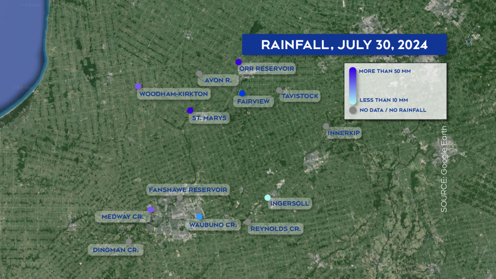
While generally a daily rain amount projected to be 40mm or higher is unusual, several sites in the Upper Thames River Conservation Authority’s (UTRCA) watershed recorded in excess of 40 and as many as 69 millimeters of rain today.
- Fanshawe Reservoir – 69 mm
- Medway River – 40.75 mm
- St. Marys – 51.2 mm
- Kirkton-Woodham – 48.4 mm
- Orr Reservoir – 51.8 mm
This is not the first time this month that the area has been walloped with rain, in fact, according to the UTRCA’s data from July, some recording sites have received as much as 258 mm more rain than is typical over the past 30 day period.
The week of July 8, rainfalls brought on by hurricane Beryl were reported to have dumped more than 100 mm of rain in only two days – well above a typical average of 55 mm for the entire month as purported by the municipality of Middlesex Centre.
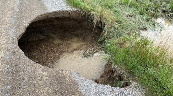
 Erosion from flooding MacEwen Dr. July 2024 (Source: Middlesex Centre)
The Municipality reported widespread surface water following rainfall on July 15, and 16, “The municipal underground system (stormwater, culverts, etc.) is not designed to handle rainfall of this intensity, and as a result we experienced surface flooding which is normal and expected under severe storm events.”
A timely venture, the City of London has several large storm water management projects in the bullseye this year, with more than 12.5 kilometers of sanitary and storm sewers tapped for replacement.
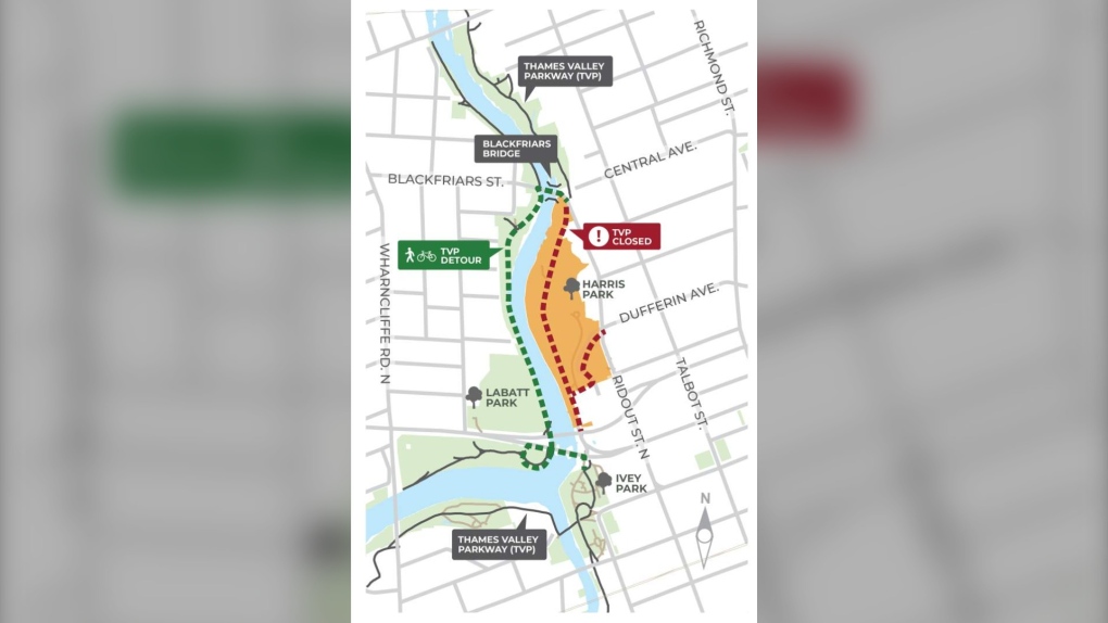
Harris Park was reported to be a mud pit once more when Rock the Park drew a record 44,000 people this year. Flooding was rampant in the days to follow, with the City of London closing many parks, playgrounds, and fields. It’s tapped for an upgrade, with new naturalised infrastructure which hopes to protect the shoreline, and several upgrades for park users.
 A map of Harris Park and the Thames Valley Parkway detour for people using the multi-use path (Source: City of London)
The Hyde Park area will also be seeing the construction of a new large storm trunk sewer, and a new storm culvert under the nearby CP rail line – providing additional erosion, flooding and storage control.
Improvements to Mud Creek also hope to continue to increase the creek’s storm water capacity – with a new wider culvert currently being installed underneath Oxford Street West near Proudfoot Lane in hopes of preventing future flooding during severe weather events.
Finally, the city is also constructing earth berms and walls around the Greenway and Adelaide Wastewater Treatment Plants later this year, which will hope to protect those facilities during flood events.
“Strong and reliable storm water infrastructure supports our rapidly growing city,” said Director, Water, Wastewater, and Storm Water Ashley Rammeloo, “Planning and constructing for the future helps our city accommodate more homes and development, while increasing our capacity for storms and flooding events."
 Rainfall recorded by the Upper Thames River Conservation Authority, July 30, 2024 (Source: Google Earth/Upper Thames River Conservation Authority)
CTVNews.ca Top Stories

Alleged gang member driving from U.S. arrested at Canadian border after making wrong turn
An alleged gang member coming from the United States was arrested at the Canadian border after reportedly making a wrong turn onto the Peace Bridge border crossing.
Kingston, Ont. doctor ordered to repay $600K for pandemic vaccination payments
An Ontario health tribunal has ordered a Kingston, Ont. doctor to repay over $600,000 to the Ontario government for improperly billing thousands of COVID-19 vaccinations at the height of the pandemic.
'Bedlam': Nova Scotia lawyer suspended following ugly courtroom fracas
A Nova Scotia lawyer who had to be restrained by deputy sheriffs during a court appearance earlier this year has lost his appeal of a suspension following the bizarre incident.
After multiple data breaches, Yahoo settled a class-action lawsuit. The deadline to file compensation claims is approaching
Yahoo and Rogers customers in Canada have until the end of the month to claim up to $375 cash from a data breach settlement.
Wind chills of -50, snowfall of up to 50 cm: Canada's weather forecast
As the second day of December unfolds, Canadians from coast to coast are experiencing a range of wintry conditions. Here's what's happening in different parts of the country.
Neighbours who sheared tops of B.C. man's bamboo plants ordered to pay $1K in damages
A B.C. man whose neighbours lopped the tops off of four of his bamboo plants has been awarded $1,000 in damages by the province’s Civil Resolution Tribunal.
A 17-year-old player dies after collapsing during a charity hockey game in New York
A 17-year-old hockey player collapsed during a charity game in New York and later died, authorities said.
Canada lists Ansarallah, known as the Houthis, a terrorist entity
The Canadian government has listed the Yemeni militant group Ansarallah, commonly known as the Houthis, as a terrorist group in an effort to 'fight terrorism globally.'
Multiple elements contributed to fatal Chinook helicopter crash in Ottawa River, investigation concludes
The investigation into a Chinook helicopter crash near Petawawa, Ont. that killed two military pilots concludes an 'unperceived acceleration' and environmental conditions were "significant contributors" to the crash in the Ottawa River.


