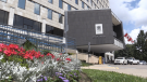
Significant snowfall expected in London, Ont. this Wednesday
 (Source: Andy Bishop)
A special weather statement is in effect for London-Middlesex and surrounding areas.
According to Environment Canada, a Texas low is expected to bring snow to southern Ontario late Wednesday into Thursday.
The area could see 10 to 15cm with reduced visibility and rapid accumulation. Some areas could see upwards of 20 cm of snow.
Other areas under the statement include Huron-Perth, Oxford-Brant, Sarnia-Lambton and Windsor-Essex.
Here's a look at London's forecast for the week
Monday: Cloudy. 40 per cent chance of flurries this morning. Fog patches dissipating this morning. High plus 1.
Monday Night: Cloudy. A few flurries beginning overnight. Local amount 2 cm. Wind becoming southwest 20 km/h gusting to 40 this evening. Low minus 4. Wind chill minus 10 overnight.
Tuesday: A few flurries ending early in the morning then cloudy with 40 per cent chance of flurries. High zero. Wind chill minus 8 in the morning.
Wednesday: Snow. High minus 1.
Thursday: Cloudy with 40 per cent chance of flurries. High minus 2.
Friday: Cloudy with 60 per cent chance of flurries. High minus 3.
Saturday: Cloudy with 60 per cent chance of flurries. High minus 3.
London Top Stories
-
-
-
-
-
-
-
 PLAYOFF TRACKER
PLAYOFF TRACKER London leads OHL finals 1-0 after win over Oshawa
-


CTVNews.ca Top Stories

Which Canadian cities have the highest and lowest grocery prices?
Where you live plays a big factor in what you pay at the grocery store. And while it's no secret the same item may have a different price depending on the store, city or province, we wanted to see just how big the differences are, and why.
'State or state-sponsored actor' believed to be behind B.C. government hacks
The head of British Columbia’s civil service has revealed that a “state or state-sponsored actor” is behind multiple cyber-security incidents against provincial government networks.
Swarm of 20,000 bees gather around woman’s car west of Toronto
A swarm of roughly 20,000 bees gathered around a woman’s car in the parking lot of Burlington Centre.
Mother assaulted by stranger while breastfeeding baby in her car: Vancouver police
A person was arrested in East Vancouver Thursday after allegedly entering a car while a mother was breastfeeding her four-month-old boy.
More than half the Canadians once detained in Syrian camps for suspected ISIS family members have returned home
A total of 29 Canadians have been freed from detention camps in northeast Syria and brought back to Canada since human rights advocates began lobbying for their release years ago.
Rare severe solar storm Friday could bring spectacular aurora light show across Canada
A rare and severe solar storm is expected to bring spectacular displays of the northern lights, also known as aurora borealis, across much of Canada and parts of the United States on Friday night.
Canada abstains from Palestinian UN membership vote but supports two-state solution
Canada was one of 25 countries that abstained from a United Nations vote on Palestinian membership that passed with overwhelming support on Friday.
Amish youth experience a rite of passage called Rumspringa. It’s not what you might think
The idea of “Rumspringa” has a specific spot in the American imagination. A rite of passage for young people in some Amish communities, Rumspringa is seen by most outsiders as a wild time away from strict Amish rules, when teenagers can experiment with the modern vices of the world.
Djokovic needs medical attention after getting knocked on the head by a water bottle at Italian Open
Novak Djokovic needed medical attention after apparently getting knocked on the head by a water bottle after a win at the Italian Open on Friday.
Shopping Trends
The Shopping Trends team is independent of the journalists at CTV News. We may earn a commission when you use our links to shop. Read about us.


Kitchener
-

9-year-old prodigy pianist to perform with former K-W Symphony musicians
A young prodigy pianist is set to perform alongside former members of the Kitchener-Waterloo Symphony, as part of a benefit concert.
-
What you should keep in your emergency supply kit
Could you survive for 72 hours following a natural disaster? The Region of Waterloo is hoping that question sparks a conversation around emergency preparedness.
-
Ontario coroner to investigate death of man who suffered cardiac arrest while waiting in ER
A provincial coroner will be investigating the death of 68-year-old David Lippert, who suffered a cardiac arrest while waiting in a crowded emergency room in Kitchener, Ont.
Windsor
-

Windsor’s unemployment rate jumps back into highest in Canada
The unemployment rate in Windsor increased dramatically last month and is the highest in Canada, according to Statistics Canada.
-
City of Windsor has unanswered questions as feds, province spar over housing funding
A dispute between the federal and provincial governments over the National Housing Strategy nearly put the City of Windsor $7 million in the hole and questions still remain over when and how much funding the city will receive.
-
Highway 401 ramps at Queens Line closed after crash
OPP are informing the public of a crash on the Highway 401 ramps at Queens Line in Chatham-Kent.
Barrie
-
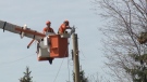
OPP probes $50,000 damage to Hydro One infrastructure in Muskoka
Provincial police are investigating after extensive damage was done to Hydro One equipment in Muskoka.
-
Here's why your yard waste may have been sitting at the curb for days
A recent change in curbside collection has left some green-thumbed enthusiasts scratching their heads as bags of yard waste linger by the curb, awaiting pickup.
-
Wasaga Beach assault turns into murder investigation after victim's death
The charge against a Wasaga Beach man has been upgraded to second-degree murder after police say the victim died more than two months after an alleged assault.
Northern Ontario
-
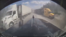
Dashcam video shows terrifying near-miss on two-lane northern Ontario highway
There were some scary moments for several people on a northern Ontario highway caught on video Thursday after a chain reaction following a truck fire.
-
Twenty defendants fined $222K for northern Ont. moose hunt violations
A large group of Canadian and U.S. defendants have been fined $178,400 plus $44,525 in surcharges for a variety of moose hunting violations in northwestern Ontario.
-
Radical anti-government rhetoric appears in northern Ont. court case
A northern Ontario couple who ran afoul of Ontario’s building code used arguments reminiscent of radical anti-government groups in a failed attempt to defend their stance in court.
Ottawa
-

Ottawa man charged in connection to fatal shooting at Manor Park home
A 20-year-old man is facing a charge of second-degree murder in connection to a fatal shooting during a poker game in Ottawa's Manor Park neighbourhood.
-
'The whole community is devastated': Sharbot Lake, Ont. mourning the death of teen in crash
A high school student at Granite Ridge Education Centre in Sharbot Lake, Ont. died in a single-vehicle crash on Thursday. Five other students were injured in the crash.
-
Ottawa's 3-container limit for curbside garbage takes effect this fall
The City of Ottawa's new three-garbage item limit for household waste will take effect on Sept. 30, with a three-month phase-in period for the limit. As of December, collection staff will only collect three garbage items from households every two weeks.
Toronto
-

Swarm of 20,000 bees gather around woman’s car west of Toronto
A swarm of roughly 20,000 bees gathered around a woman’s car in the parking lot of Burlington Centre.
-
'Just wait': Toronto mayor hints that WNBA team is coming to the city amid multiple reports
Toronto Mayor Olivia Chow says that she is hopeful an announcement could be made soon amid multiple reports that a WNBA team is coming to Toronto in 2026.
-
What to know about road and transit closures in Toronto this weekend, May 11-12
Here are the road closures in Toronto this weekend to keep in mind.
Montreal
-
 BREAKING
BREAKING McGill University seeks injunction to remove pro-Palestinian encampment from campus
McGill University has filed a request for an injunction to have the pro-Palestinian encampment removed from its campus.
-
Man charged after truck strikes and kills driver changing flat tire on side of Montreal-area highway
A 43-year-old man has been charged after a driver was struck and killed while changing a tire on the side of a Highway 15 near Montreal on Thursday.
-
This iconic Canadian song is turning 50
Andy Kim's 'Rock Me Gently' is marking a major milestone, as it celebrates its 50th anniversary.
Atlantic
-

Seven people charged following kidnapping, assault in Tobique First Nation: N.B. RCMP
RCMP say seven people have been arrested and charged in connection with a kidnapping and assault in Tobique First Nation, N.B.
-
Pharmacy care clinic expansion under review in New Brunswick
New Brunswick rolled out six pharmacy clinics in August and September last year and feedback has been mostly very positive.
-
EHS helicopters to land in new spot in Halifax
Emergency Health Services (EHS) LifeFlight helicopters will soon be landing at Canadian Forces Base Windsor Park in the Halifax's west end.
Winnipeg
-

'Devastating': Businesses concerned over watercraft ban on Clear Lake
Businesses in the Clear Lake area are concerned about the future following a temporary ban on watercraft from entering the lake.
-
Roughly 250 people forced to evacuate Winnipeg apartment building deemed unsafe
Approximately 250 residents of a St. James area apartment building will have to leave their homes immediately, as the City of Winnipeg issued a vacate order over unsafe conditions.
-
Solar storm could produce highly visible northern lights in Manitoba
An unusually large solar storm could produce northern light shows that may be visible across most of Canada on Friday and Saturday.
Calgary
-

City of Chestermere inspection reveals ‘irregular, improper and improvident’ financial management: province
A third-party examination of the City of Chestermere revealed “significant gaps” in the financial management, the province said Friday.
-
'We have laws': Premier Smith says police action justified in Calgary
The actions, including the decision to use non-lethal force, to disperse pro-Palestinian protesters from the University of Calgary campus were justified, Alberta Premier Danielle Smith said Friday.
-
Calgary approves all 28 recommendations from downtown safety panel
The City of Calgary has approved more than two-dozen recommendations to improve safety and vibrancy in the downtown core.
Edmonton
-

'Violent, despicable and unbelievable': Family of murdered 7-year-old speak at David Moss sentencing Friday
David Moss, the man who murdered seven-year-old Bella Rose Desrosiers, broke down in court Friday as the girl's family spoke about the toll her death has taken on them.
-
Oilers star Leon Draisaitl questionable for Game 2 vs. Canucks
Edmonton Oilers star Leon Draisaitl is questionable for today's Game 2 against the Vancouver Canucks.
-
Out-of-control wildfire burning near Fort McMurray
As of 9 a.m. on Friday, the wildfire burning 28 kilometres southwest of the northeastern Alberta city was 25 hectares in size.
Vancouver
-

'State or state-sponsored actor' believed to be behind B.C. government hacks
The head of British Columbia’s civil service has revealed that a “state or state-sponsored actor” is behind multiple cyber-security incidents against provincial government networks.
-
B.C. finance minister says she will retire following provincial election this fall
British Columbia's finance minister says she won't be running again in the next provincial election after serving in the legislature for nearly two decades.
-
Check your storage lockers, Coquitlam RCMP warn after recovering stolen memorabilia worth $50K
Mounties in Coquitlam are asking people to check their storage lockers after recovering more than $50,000 worth of stolen sports memorabilia last weekend.


