Tornado, severe thunderstorm watches and warnings lifted for region
 The sky over southwest London as seen on June 25, 2023. (Source: Keriann O'Rourke)
It's been a chaotic Friday evening with Environment Canada issuing and downgrading a multitude of tornado watches and warnings, and severe thunderstorm watches and warnings across the region.
According to Environment Canada, all previously issued tornado watches and warnings, and severe thunderstorm watches and warnings have been lifted for the counties of Grey-Bruce and Huron-Perth.
Meanwhile, smoke plumes from forest fires over northeastern Ontario and Quebec will continue to affect the area, with Grey-Bruce, Huron-Perth, Oxford-Brant, and Sarnia-Lambton still remaining under special air quality statements late Friday, according to Environment Canada.
Wildfire smoke can be harmful to everyone’s health even at low concentrations, with children, seniors, pregnant people and those with cardiovascular or lung disease being at particular risk.
Heat and humidity will also dominate the long weekend forecast with the thermometer reading high 20s but feeling like mid-30s.
Here's a look at the rest of the forecast
Friday night: Partly cloudy. 40 per cent chance of showers this evening and after midnight with risk of a thunderstorm. Low 18.
Saturday: Cloudy. Becoming a mix of sun and cloud late in the morning with a 60 per cent chance of showers in the afternoon with risk of a thunderstorm. High 30. Humidex 35. UV index 10 or very high.
Sunday: Cloudy with 60 per cent chance of showers. High 24.
Monday: Cloudy with 30 per cent chance of showers. High 25.
Tuesday: Sunny. High 29.
Wednesday: A mix of sun and cloud with 30 per cent chance of showers. High 26.


CTVNews.ca Top Stories
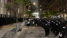
Large numbers of New York City police officers begin entering Columbia University campus
Large numbers of New York City police officers began entering the Columbia University late Tuesday as dozens of pro-Palestinian protesters remained on the campus.
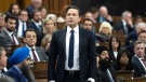
Poilievre kicked out of Commons after calling Prime Minister Justin Trudeau 'wacko'
Testy exchanges between the prime minister and his chief opponent ended with the Opposition leader and one of his MPs being ejected from the House of Commons on Tuesday -- and the rest of Conservative caucus walking out of the chamber in protest.
Baby, grandparents among 4 people killed in wrong-way police chase on Ontario's Hwy. 401
A police chase which started with a liquor store robbery in Bowmanville Monday night ended in tragedy some 20 minutes later when a suspect fleeing police entered Highway 401 in the wrong direction and caused a pileup which killed an infant and the child's grandparents, as well as the suspect, investigators say.
Freeland leaves capital gains tax change out of coming budget implementation bill, here's why
Deputy Prime Minister and Finance Minister Chrystia Freeland will be tabling yet another omnibus bill to pass a sweeping range of measures promised in her April 16 federal budget, though left out of the legislation will be the government's proposed capital gains tax change.
Sword-wielding man attacks passersby in London, killing a 14-year-old boy and injuring 4 others
A man wielding a sword attacked members of the public and police officers in a northeast London suburb Tuesday, killing a 14-year-old boy and injuring four other people, British authorities said.
Man dies after suffering cardiac arrest while waiting in ER, widow wants investigation
When an ambulance took David Lippert to the hospital in March of 2023, the 68-year-old Kitchener, Ont., executive was hoping to find out why he was feeling weak and unable to walk. Some 24 hours later, he was found unresponsive in the ER.
CSE says it shared information on Chinese hacking of parliamentarians in 2022
While several MPs and senators say they were only recently made aware of China-backed hackers targeting them, the Communications Security Establishment, one of Canada's intelligence agencies, says it shared information about the incident with parliamentary officials in June of 2022.
WATCH
WATCH Arnold Schwarzenegger spotted filming in Elora, Ont.
The name of the project has not been officially released although it’s widely believed to be the Netflix series FUBAR.
Eviction for landlord's use was legitimate, despite owners' partial move, B.C. court rules
A B.C. judge has upheld the eviction of a family from their North Vancouver townhouse, finding that the landlords did not take an unreasonable amount of time to move into the home after the tenants vacated it.
Shopping Trends
The Shopping Trends team is independent of the journalists at CTV News. We may earn a commission when you use our links to shop. Read about us.