A wet end to the week in the London region
Unsettled conditions are expected Friday as a warm front moves into the region.
"We do have the chance of showers and the possibility of a thunderstorm," said CTV News London meteorologist Julie Atchison. "Showers will linger as we head into Friday evening with some spotty rainfall happening in midwestern Ontario and more steady rain towards the Bruce Peninsula."
The weekend starts cloudy with a chance of showers on Saturday but dry periods appear as we head into Saturday afternoon.
Temperatures will hold on the warm side over the next seven days with highs in the low 20s and lows all above 10 C.
Here's a look at the rest of the forecast
Friday: Cloudy. Showers beginning early this morning and ending near noon then 40 per cent chance of showers this afternoon. Risk of a thunderstorm. Local amount 15 to 25 mm. High 21.
Friday Night: Mainly cloudy. 70 per cent chance of showers changing to 30 percent chance of showers or drizzle near midnight. Risk of a thunderstorm this evening. Low 12.
Saturday: Mainly cloudy. 30 per cent chance of showers or drizzle in the morning. High 24. Humidex 29
Sunday: Cloudy with 60 per cent chance of showers. High 21.
Monday: Sunny. High 22.
Tuesday: Cloudy with 30 per cent chance of showers. High 22.
Wednesday: Cloudy with 40 per cent chance of showers. High 24.
London Top Stories
-
-
-
 BREAKING
BREAKING Windsor Regional Hospital CEO David Musyj heading to LHSC
-
-
-
-
-


CTVNews.ca Top Stories
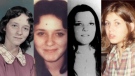
Serial sexual offender linked to unsolved 1970s homicides of four Calgary girls, women
An investigation into unsolved historical homicides from the 1970s has linked the deaths of two girls and two young women in and around Calgary to a now-deceased serial offender.
Woman with liver failure rejected for a transplant after medical review highlights alcohol use
For nearly three months, Amanda Huska has been in an Ontario hospital, part of it on life support, because of severe liver failure. Her history of alcohol use is getting in the way of her only potential treatment: a liver transplant.
Video appears to show Sean 'Diddy' Combs beating singer Cassie in hotel hallway in 2016
Security video aired by CNN appears to show Sean 'Diddy' Combs physically assaulting singer Cassie in a Los Angeles hotel hallway in 2016.
Scottie Scheffler isn't the first pro golfer to be arrested during a tournament
Scottie Scheffler's arrest hours before his second-round tee time at the PGA Championship in Louisville, Kentucky, will go down as one of the most shocking in professional golf history. It certainly wasn't the first, though.
B.C. man 'attacked suddenly' by adult grizzly near Alberta border: RCMP
A B.C. man is recovering from multiple injuries after he was "attacked suddenly" by an adult grizzly bear near Elkford Thursday afternoon.
Anglers reel in 3.5-metre-long tiger shark off coast of Florida: 'She found my bait'
A group of fishers said it took roughly 20 minutes to reel in this 3.5-metre-long tiger shark off the coast of Florida.
Australia's richest woman seeks removal of her portrait from exhibition
Art is subjective. And while many artists long to share their work with the world, there's no guarantee that the audience will understand it, or even like it.
Canadian convicted of attacking Nancy Pelosi's husband with a hammer sentenced to 30 years
The man convicted of attempting to kidnap then-U.S. House Speaker Nancy Pelosi and attacking her husband with a hammer was sentenced Friday to 30 years in prison.
NEW
NEW What a wildfire survivor says she regrets not grabbing before leaving home
Carol Christian had 15 minutes to evacuate her home during the Fort McMurray wildfires in 2016. She ended up losing the house and everything inside. Now, she wants to share the lessons she learned.
Shopping Trends
The Shopping Trends team is independent of the journalists at CTV News. We may earn a commission when you use our links to shop. Read about us.