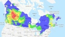
Weather watches and warnings in effect for most of the region
Even though it's the first full day of spring, there are winter-weather related watches and warnings in effect across the province.
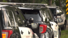
“Winter-like conditions [are] holding steady in southern Ontario and another round of snow on the way Wednesday,” said CTV News London Meteorologist Julie Atchison. “A cold front coming through [Wednesday] morning, strong winds out of the northwest will develop through the day. That means blowing snow, flurries, and the potential for some snow squalls in parts of Midwestern Ontario.”
A snow squall warning is in effect for London, Parkhill and eastern Middlesex County, while Strathroy, Komoka and western Middlesex County are under a weather advisory, warning of lake-effect snow late Wednesday and into Wednesday night.
Huron-Perth and Grey-Bruce are also under a snow squall warning and Oxford-Brant is under a special weather advisory, warning of a brief frontal snow squall.
Atchison advises motorist to be cautious while travelling in squall-like conditions, “Blowing snow will be an issue.”
She said winds will be gusting out of the northwest at 40km/h to 60km/h in the afternoon.
Here’s a look at the London, Ont. region’s forecast
Wednesday: Flurries. Local amount 2 cm. Wind northwest 20 km/h gusting to 50 increasing to 40 gusting to 60 near noon. High plus 1. Wind chill minus 9 in the afternoon.
Wednesday night: Flurries or snow squalls. Local blowing snow. Local amount 10 to 15 cm. Wind northwest 30 km/h gusting to 50. Low minus 4. Wind chill near minus 11.
Thursday: Flurries. Local blowing snow in the morning. Local amount 2 cm. Wind northwest 20 km/h gusting to 40. High minus 1. Wind chill near minus 10.
Friday: Cloudy with 70 per cent chance of flurries. High minus 2.
Saturday: A mix of sun and cloud. High plus 2.
Sunday: A mix of sun and cloud. High zero.
Monday: Cloudy. High plus 3.
London Top Stories
-
-
-
-
-
 PLAYOFF TRACKER
PLAYOFF TRACKER London Knights lead OHL Finals 3-0 after forcing overtime in Oshawa
-
-
-


CTVNews.ca Top Stories
Latest updates on air quality alerts, and when the smoke may reach Ontario and Quebec
Wildfires have led Environment Canada to issue air quality advisories for parts of B.C., Alberta, Manitoba, Saskatchewan and the Northwest Territories, as forecasters warn the smoke could drift farther east.
Ellen DeGeneres addresses the 'hurtful' end of her talk show in new stand-up set
Ellen DeGeneres is reflecting on how her talk show came to an end in her newest Netflix special, 'Ellen's Last Stand ... Up Tour.'
Steal a car, lose your driver's licence under new Ontario proposal
Repeat car thieves may face lengthy licence bans under proposed changes to Ontario’s Highway Traffic Act.
B.C. brings in law on name changes on day that child killer's new identity revealed
The BC NDP have tabled legislation aimed at stopping people who have committed certain heinous acts from changing their names.
What to pack during an emergency
Knowing what to have at home, or take with you for an evacuation, can be useful and even life-saving.
Significant police presence as Israeli flag flies at Ottawa City Hall
The Israeli flag is flying at Ottawa City Hall today to mark the country's national day, with plans to hold a private ceremony to mark Israel's Independence Day. There is a significant police presence at City Hall, including security barriers outside the main doors.
Regulated area for invasive box tree moth expanded to parts of the Maritimes
The Canadian Food Inspection Agency has added much of the Maritimes to a regulated area for an invasive species.
Already expensive, planning for fertility treatment difficult as costs vary widely
Being unable to have a child naturally can be extremely difficult. But when you factor in the high costs of fertility treatments, the range of individual circumstances and the fact that the industry itself is secretive about fees, it can make the whole ordeal even more devastating and hard to plan for.
A healthy lifestyle can mitigate genetic risk for early death by 62%, study suggests
Even if your genetics put you at greater risk for early death, a healthy lifestyle could help you significantly combat it, according to a new study.
Shopping Trends
The Shopping Trends team is independent of the journalists at CTV News. We may earn a commission when you use our links to shop. Read about us.


Kitchener
-
Kitchener city council votes to give THEMUSEUM $300K to stay open
Kitchener city councillors voted in favour of giving THEMUSEUM $300,000 to avoid being forced to close.
-
A dozen people displaced, $150K in damage after Cambridge apartment fire
Red Cross is helping 12 people who were displaced following an apartment fire in Cambridge.
-
Guelph police make second arrest in baseball bat attack
A second Guelph man has been arrested and charged in relation to a serious assault in March that left the victim with two broken arms and a leg, Guelph police said Tuesday.
Windsor
-

Windsor murder suspect arrested after repeated bail violations
Windsor police bail compliance members have arrested a 24-year-old murder suspect following repeated violations of his bail conditions after he was charged in 2018.
-
Chatham-Kent Council approves expansion of 'Birds Eye View' police surveillance program
Chatham-Kent council approved the expansion of several closed-circuit televisions systems across the municipality Monday evening.
-
Crossing guard changes to be considered in Tecumseh
Tecumseh Council approved recommendations directing administration to coordinate information sessions with the local schools affected by a possible change in approach to crossing guards.
Barrie
-

Thunderstorm rocked Simcoe County with toonie-sized hail, downpours
Simcoe County was under a severe thunderstorm warning with the potential for strong winds up to 90 kilometres per hour, toonie-sized hail, and heavy downpours on Monday.
-
Mother of 2 killed in Innisfil crash
Young mother was killed in a two-vehicle crash in Innisfil Saturday morning.
-
Barrie boy arrested after alleged assault leaves female victim hospitalized
A Barrie teen faces serious charges after an alleged altercation in a parking lot that police say sent a female to the hospital.
Northern Ontario
-

Ellen DeGeneres addresses the 'hurtful' end of her talk show in new stand-up set
Ellen DeGeneres is reflecting on how her talk show came to an end in her newest Netflix special, 'Ellen's Last Stand ... Up Tour.'
-
North Bay police looking for third suspect in business break-in
With two suspects in custody, North Bay police are asking the public for help in identifying a third accused of breaking into a downtown business.
-
Western University researchers unlock potential 'cure' for ALS
New research out of London, Ont.'s Western University is shedding light on a potential cure for ALS, with the goal of conducting human clinical trials within the next five years.
Ottawa
-

Child dies after being struck by a school bus in Rockland, Ont.
An 11-year-old child has died after being struck by a school bus while bicycling in Rockland, Ont., according to police.
-
Significant police presence as Israeli flag flies at Ottawa City Hall
The Israeli flag is flying at Ottawa City Hall today to mark the country's national day, with plans to hold a private ceremony to mark Israel's Independence Day. There is a significant police presence at City Hall, including security barriers outside the main doors.
-
BREAKING
BREAKING 4 injured, including 2 critical, after Hwy. 417 crash in Ottawa's west end
Ontario Provincial Police are responding to a serious collision involving two vehicles on Highway 417 in Ottawa's west end on Tuesday morning.
Toronto
-
Steal a car, lose your driver's licence under new Ontario proposal
Repeat car thieves may face lengthy licence bans under proposed changes to Ontario’s Highway Traffic Act.
-
GARDINER GRIDLOCK
GARDINER GRIDLOCK 'It's just been a nightmare': Gardiner restrictions are Toronto's traffic tipping point
In the first of a three-part series on Gardiner Gridlock, CTV Toronto examines the impact that the three-year cut to capacity on the downtown expressway is having on commuters – and their outcry.
-
'A significant increase:' Lice removal companies say they are seeing a surge in infestations
After nearly 15 years in business, Shawnda Walker said the past 12 months has been the busiest year yet for her North York head lice removal company.
Montreal
-

Montreal businesses apologize after video shows man throw water on sleeping homeless person
Two Montreal businesses are apologizing after a video circulating on social media showed a man throwing water on a homeless person sleeping outside of a Chinatown storefront.
-
New modular ER opening at Lakeshore General Hospital
The Lakeshore General Hospital in Montreal's West Island announced it will be opening a temporary emergency room while major renovations get underway.
-
McGill University encampment: judge expected to deliver injunction decision Tuesday
Pro-Palestinian protesters at McGill University have become 'occupiers' living in a fortified and barricaded mini-village, a lawyer for the Montreal school argued on Monday as he asked for an injunction to dismantle the more than two-week-old encampment on its downtown campus.
Atlantic
-

TLC cancels Moncton concert after tour members, including lead singer, fall ill
TLC fans looking forward to their concert in Moncton, N.B., on Tuesday will be disappointed to find out that the show has been cancelled due to illness.
-
Halifax restaurant named one of the best in Canada
A Halifax restaurant has been named as one of the best in the country.
-
Regulated area for invasive box tree moth expanded to parts of the Maritimes
The Canadian Food Inspection Agency has added much of the Maritimes to a regulated area for an invasive species.
Winnipeg
-
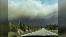
'Never seen a fire move like this': Manitoba wildfire now at 31,500 hectares
Fire crews are continuing to battle a significant blaze in Manitoba’s north that has prompted evacuations.
-
These three Winnipeg restaurants have been named as some of Canada's best
A trio of Winnipeg restaurants have been named as some of the best in the country.
-
Trial of Winnipeg serial killer expected to hear testimony from DNA expert
The Winnipeg trial of admitted serial killer Jeremy Skibicki is expected to continue today with testimony from a DNA expert.
Calgary
-

Calgary police chief says actions against pro-Palestinian protest were 'prudent'
Calgary's top cop is standing by the officers involved in clearing a pro-Palestinian protest at the University of Calgary last week.
-
WEATHER
WEATHER Westerly flow will offer reprieve in wildfire smoke
Showers will continue in southern Alberta in the morning Tuesday and there is a chance non-severe thunderstorms will develop in southeastern Alberta throughout the day.
-
Man seriously injured in crash near Okotoks dies in hospital
A man who was seriously injured in a crash near Okotoks almost two weeks ago has died.
Edmonton
-
Man's death in fight ruled homicide after autopsy
The death of a man in a central Edmonton fight is being investigated as a homicide. A 34-year-old man was charged with second-degree murder.
-
Wanted (desperately): Secondary scoring by Oilers forwards
Can a National Hockey League coach play his top forwards half the game? Of course. It happened in the most recent Edmonton Oilers game when bench boss Kris Knoblauch ran stars Connor McDavid and Leon Draisaitl 29:42 and 29:04, respectively, over the 60 minutes played in Sunday's regulation 4-3 playoff loss to the Vancouver Canucks.
-
Calls for more spending on Alberta health care following senior's 3-week stay in hospital hallway
A woman whose 81-year-old father recently spent three weeks receiving care in an Edmonton hospital hallway is joining the Alberta NDP to call for better care, including more health-care workers, and a south Edmonton hospital.
Vancouver
-

Hollywood stars descend on B.C. castle for 'Fate' film
A British Columbia castle is hosting Hollywood royalty this week as filming gets underway on a supernatural love story spanning seven decades.
-
Wildfire burning near Fort Nelson, B.C., continues to rapidly grow
A wildfire in the community of Fort Nelson has significantly expanded as residents in British Columbia's northeast receive more mandatory evacuation orders.
-
Honda Celebration of Light cancels annual news conference due to B.C.'s wildfires
Event organizers for the Honda Celebration of Light cancelled an annual news conference "out of respect" for B.C. communities facing wildfire threats.


