Beachville, Ont. funnel cloud a confirmed tornado: Northern Tornadoes Project
A reported funnel cloud seen over Beachville earlier this week has been confirmed as an EF0 tornado, according to Western University’s Northern Tornadoes Project.
According to Western University’s Northern Tornadoes Project, observations of a funnel cloud seen overhead in Beachville, located west of Woodstock, were reported on the evening of June 13.
Initial surveys deemed the Beachville funnel cloud did not manifest into a tornado, as a ground and drone survey conducted of the area did not locate any damage. Also compounding this was viewer footage and photos which showed an obscured view of the ground, therefore preventing confirmation of the funnel cloud touching ground.
However, the Northern Tornadoes Project later obtained viewer video that captured the funnel cloud and an unobstructed view of the ground, proving surface circulation “between trees when the tornado very briefly intensified, causing the funnel cloud to extend close to the surface.”
With this new information, the Northern Tornadoes Project has deemed the Beachville funnel cloud to be a confirmed tornado, and rated it as an EF0.
Because no damage indicators on the EF (Enhanced Fujita) scale were hit, the tornado was given a default rating of EF0.
The estimated track length, width and tornado motion remain unclear at this time, with a satellite imagery review currently pending.
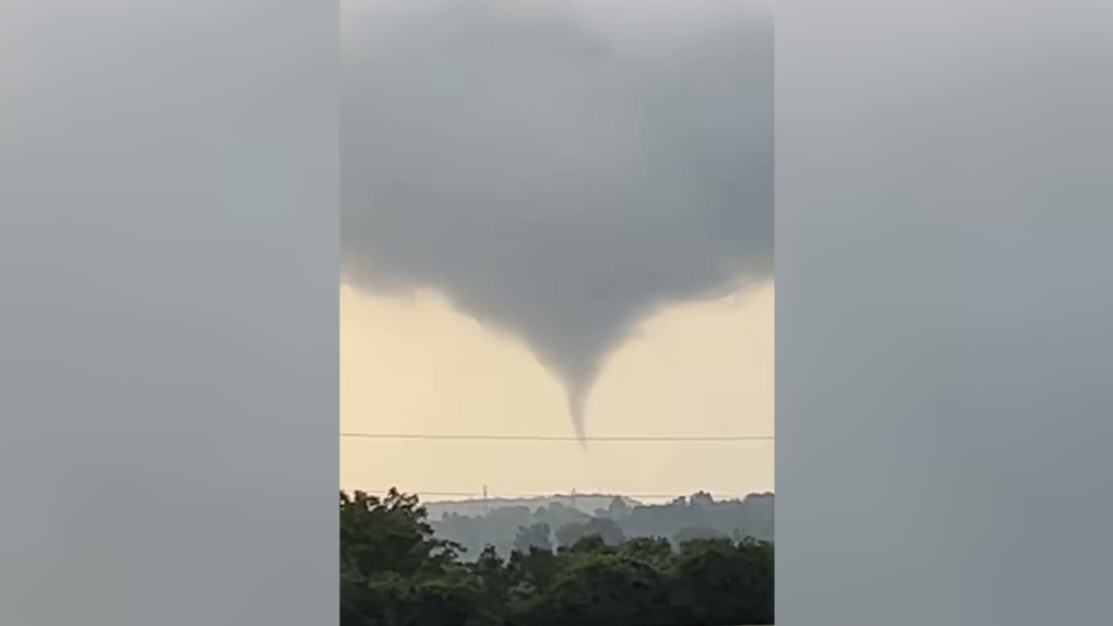 A funnel cloud seen near Beachville, Ont. on June 13, 2023. (Source: Kennedy Kaufman)
A STORMY TUESDAY
Environment Canada had issued a tornado warning that night for the region of Oxford-Brant, including in Woodstock and Tillsonburg.
The wicked storms also sparked an EF0 tornado in Talbotville, Ont., located west of St. Thomas. In London-Middlesex, a severe thunderstorm warning had been issued, with powerful thunder, bolts of lightning and hail being observed.
Shopping Trends
The Shopping Trends team is independent of the journalists at CTV News. We may earn a commission when you use our links to shop. Read about us.


CTVNews.ca Top Stories

Donald Trump says he urged Wayne Gretzky to run for prime minister in Christmas visit
U.S. president-elect Donald Trump says he told Canadian hockey legend Wayne Gretzky he should run for prime minister during a Christmas visit but adds that the athlete declined interest in politics.
Ho! Ho! HOLY that's cold! Montreal boogie boarder in Santa suit hits St. Lawrence waters
Montreal body surfer Carlos Hebert-Plante boogie boards all year round, and donned a Santa Claus suit to hit the water on Christmas Day in -14 degree Celsius weather.
Historical mysteries solved by science in 2024
This year, scientists were able to pull back the curtain on mysteries surrounding figures across history, both known and unknown, to reveal more about their unique stories.
Montreal man dead after boat explodes in Fort Lauderdale
A Montreal man is dead and several others are injured after a boat exploded in Fort Lauderdale, Florida.
Mother-daughter duo pursuing university dreams at the same time
For one University of Windsor student, what is typically a chance to gain independence from her parents has become a chance to spend more time with her biggest cheerleader — her mom.
Azerbaijani airliner crashes in Kazakhstan, killing 38 with 29 survivors, officials say
An Azerbaijani airliner with 67 people onboard crashed Wednesday near the Kazakhstani city of Aktau, killing 38 people and leaving 29 survivors, a Kazakh official said.
King Charles III focuses Christmas message on healthcare workers in year marked by royal illnesses
King Charles III used his annual Christmas message Wednesday to hail the selflessness of those who have cared for him and the Princess of Wales this year, after both were diagnosed with cancer.
Alberta premier hopes for health reform payoff in 2025, regrets deferring tax cut
"It may have been better for Albertans if we'd implemented and then found a way to be able to pay for it."
NFL's Netflix debut on Christmas Day kicked off without a glitch
Mariah Carey opened Wednesday’s doubleheader with a taped performance of “All I Want for Christmas is You” before Patrick Mahomes, Travis Kelce and the two-time defending Super Bowl champion Kansas City Chiefs faced off against Russell Wilson, T.J. Watt and the Pittsburgh Steelers.
Kitchener
-

Feel-good stories of 2024: Dramatic dog rescue, Guelph toddler gets transplant and lost letters returned
Before we say goodbye to 2024, let’s look back at some of the good news stories we brought to you this year.
-
Why holiday shopping may feel a little different this year
At around 11 a.m. Tuesday at Kitchener’s Fairview Park Mall, there were plenty of parking spots available. It’s a sign that maybe this year, the rush for last minute gifts is no more.
-
How to stay safe during the holiday season
As fun festivities begin, the Canadian government, SickKids and fire departments in the Waterloo Region are reminding families of the higher safety risks during the holiday season.
Barrie
-

Here's when Santa is coming down your chimney, live tracking underway in Simcoe County
The spirit of Christmas is in the air as Santa Claus begins his lasting journey to deliver presents to children around the region.
-
Help this missing pup make it home for Christmas
The Ontario SPCA in Barrie needs your help bringing this handsome pup home to his family before Christmas.
-
Last minute shoppers braced for chaos but found calm on Christmas Eve
Many shoppers were out on Christmas Eve, and while the rush was expected to be chaotic, many found the day surprisingly manageable.
Windsor
-

Mother-daughter duo pursuing university dreams at the same time
For one University of Windsor student, what is typically a chance to gain independence from her parents has become a chance to spend more time with her biggest cheerleader — her mom.
-
VIDEO
VIDEO From a repaired stuffed animal to an ATV, shoppers reveal the best gift they have ever received
We asked people of all ages getting in some last-minute Christmas Eve shopping inside Windsor’s Devonshire Mall to talk about the best present they've ever received — and their answers might just warm your heart this holiday season.
-
'We may have to look at other sensible locations': Where will Windsor’s new H4 be located?
The search for a site to house Windsor’s new Homelessness and Housing Help Hub (H4) is back underway after the city scrapped plans at 700 Wellington Avenue on Monday.
Northern Ontario
-

Indigenous family faced discrimination in North Bay, Ont., when they were kicked off transit bus
Ontario's Human Rights Tribunal has awarded members of an Indigenous family in North Bay $15,000 each after it ruled they were victims of discrimination.
-
Quebec suspect charged with stunt driving in northern Ont.
A 25-year-old from Notre Dame du Nord, Que., has been charged with stunt driving, police in Temiskaming said Tuesday.
-
Dismiss Trump taunts, expert says after 'churlish' social media posts about Canada
U.S. president-elect Donald Trump and those in his corner continue to send out strong messages about Canada.
Sault Ste. Marie
-

Sault shopper caught with stolen credit cards
A Sault man’s illegal shopping spree came to an abrupt end over the weekend.
-
Ontario First Nation challenging selection of underground nuclear waste site in court
A First Nation in northern Ontario is challenging the selection of a nearby region as the site of a deep geological repository that will hold Canada's nuclear waste, arguing in a court filing that it should have had a say in the matter as the site falls "squarely" within its territory.
-
Sault man arrested after security guard kicked in the head over the weekend, police say
A 36-year-old Sault man was arrested Christmas Eve following an incident over the weekend.
Ottawa
-

Ottawa G1 driver caught driving uninsured, unaccompanied with out-of-service plate on HWY 417
A G1 driver is facing multiple charges after being stopped on Highway 417 in Ottawa for out-of-service licence plate Wednesday, according to the Ontario Provincial Police (OPP).
-
YEAR-IN-REVIEW
YEAR-IN-REVIEW Top stories in Ottawa in 2024
It was a year of change in Ottawa in 2024, with federal public servants required to spend more time in the office, alcohol now available in grocery stores and gas stations, and the Ottawa Senators taking the next step towards moving downtown.
-
What's open and closed in Ottawa over the holidays
CTVNewsOttawa.ca takes a look at what's open and closed over the Christmas and New Year's holidays this year.
Toronto
-

Man dead, woman in hospital after overnight housefire in Scarborough
An elderly man has died after being pulled from a two-alarm house fire in Scarborough Christmas morning.
-
Woman rushed to hospital after being pulled from Davisville apartment fire
An elderly woman was rushed to hospital with life-threatening injuries after being pulled from an apartment fire in the Davisville Village area Christmas Eve.
-
'A strong woman who never gave up': East Toronto neighbourhood shaken by death of unhoused resident
People in Toronto’s east end are shaken after a well-known unhoused woman from the community reportedly died over the weekend.
Montreal
-

Ho! Ho! HOLY that's cold! Montreal boogie boarder in Santa suit hits St. Lawrence waters
Montreal body surfer Carlos Hebert-Plante boogie boards all year round, and donned a Santa Claus suit to hit the water on Christmas Day in -14 degree Celsius weather.
-
Montreal man dead after boat explodes in Fort Lauderdale
A Montreal man is dead and several others are injured after a boat exploded in Fort Lauderdale, Florida.
-
54-year-old woman dies after getting trapped under a vehicle exiting driveway
A 54-year-old pedestrian who was struck by a vehicle exiting a driveway in Montreal's Lachine borough has died.
Atlantic
-

Two deaths in Truro ruled homicides: RCMP
Police in Nova Scotia are investigating after two deaths in Truro, N.S., over the weekend have been ruled homicides.
-
Snow forecast through Christmas Eve for parts of the Maritimes
Parts of the Maritimes that were hit by a weekend snowstorm are in for more of the white stuff this Christmas Eve.
-
'Can I taste it?': Rare $55,000 bottle of spirits for sale in Moncton, N.B.
A rare bottle of Scotch whisky is for sale in downtown Moncton, N.B., with a price tag reading $55,000.
Winnipeg
-

'They gambled with trees': Cutting down trees resumes in Lemay Forest
The next chapter of the Lemay Forest saga has unfolded as the sounds of trees coming down could be heard Monday.
-
One person dead, another injured following Monday night house fire
One person has died and another is in unstable condition following a house fire Monday evening.
-
Winnipeg police investigating string of packages being stolen
The Winnipeg Police Service is investigating a string of package thefts in the Transcona area.
Calgary
-

Alberta premier Danielle Smith issues Christmas and Hannukkah greetings Wednesday
Alberta premier Danielle Smith wished Albertans a merry Christmas and a happy Hannukkah Wednesday.
-
A year of ‘high highs and some real lows’: NDP leader Naheed Nenshi sends holiday greetings to Albertans
Alberta NDP leader Naheed Nenshi ended a year unlike any other in his career, sending out holiday wishes to everyone in the province.
-
Lethbridge Polytechnic set to host crop conference as school ranked in Top 10 Canadian research colleges
Lethbridge Polytechnic is set to host a major conference next month on an irrigated crops update, just as the school has been recognized as a top national research institution.
Edmonton
-

Alberta premier hopes for health reform payoff in 2025, regrets deferring tax cut
"It may have been better for Albertans if we'd implemented and then found a way to be able to pay for it."
-
A year of ‘high highs and some real lows’: NDP leader Naheed Nenshi sends holiday greetings to Albertans
Alberta NDP leader Naheed Nenshi ended a year unlike any other in his career, sending out holiday wishes to everyone in the province.
-
Alberta premier Danielle Smith issues Christmas and Hannukkah greetings Wednesday
Alberta premier Danielle Smith wished Albertans a merry Christmas and a happy Hannukkah Wednesday.
Regina
-

Pedestrian collision sends man to hospital with life-threatening injuries
One man has been sent to hospital with life-threatening injuries after he was struck by a vehicle in the early hours of Wednesday in Regina.
-
Here's what's open and what's closed in Regina this holiday season
Here's what residents can expect in terms of city services as Regina slides right into the Christmas holidays.
-
This miniature village is a Christmas tradition for one Regina family
A miniature Christmas village made of decorative houses and buildings has been slowly growing in a Regina home.
Saskatoon
-

'People prop the doors open': Saskatoon resident concerned as people shelter in her stairwell
With the number of homeless people in Saskatoon at an unprecedented high, it’s no surprise people are looking for places to warm up.
-
Sask. highway closed following serious collision
The Saskatchewan RCMP are investigating a serious collision on Highway 7, approximately 15 kilometres west of Rosetown.
-
A separate Ukrainian Christmas may be a thing of the past
There might be more households than usual celebrating this Christmas Eve, as many Ukrainians around the world are opting to abandon the orthodox calendar.
Vancouver
-

Passenger dead following pickup truck crash in Surrey, B.C.
A section of B.C.’s Highway 15 has closed following a crash that killed a person Christmas Day.
-
Homegrown gift-giving initiative makes Christmas morning magic for families in need
On Christmas morning, hundreds of families throughout the Lower Mainland who otherwise might not have had anything to open were given sackfuls of brightly wrapped gifts to unwrap with their families, courtesy of a grassroots charity ran by one Surrey woman.
-
Motorcyclist dead following Kitsilano, Christmas Eve crash
A motorcyclist has died following a crash in Vancouver’s Kitsilano Christmas Eve.
Vancouver Island
-

BC Ferries cancels many Christmas Day sailings, says others 'at risk'
The stormy weather in the forecast for B.C.'s South Coast is already disrupting many Christmas Day travel plans.
-
Janitors at Vancouver airport ratify deal with employer, end strike
The janitors who clean the Vancouver International Airport have ratified a new collective agreement with their employer, ending their strike on Christmas Eve.
-
Gas leaking after truck crash in Port Moody not ammonia, police say
There were tense moments for first responders in Port Moody on Christmas Eve, after a commercial truck crashed and began leaking gas.


