Winter weather travel advisory in effect for London region
A winter weather travel advisory has been issued for parts of the region.
The snow will start Friday morning in London, Ont., moving east and reaching the Niagara region by Friday afternoon.
Snowfall amounts will range between 10 to 15 cm and visibility will be reduced as the winds pick up out of the northeast.
The low-pressure system will move from the mid Mississippi valley into the Ohio valley late Thursday evening pulling an area of moisture northward.
The storm will brush by to the south of the lower lakes with snow and strong winds, affecting both your morning and evening commute Friday.
Snow will wind down Friday evening after 6pm, as the main area of moisture moves out.
The forecast track could change as the system moves in Friday morning and upgrades to snowfall warnings may be issued.
Here’s a look at the forecast:
Thursday Night: Mainly cloudy. Wind becoming east 20 km/h overnight. Low minus 2. Wind chill minus 8 overnight.
Friday: Snow beginning in the morning. Amount 10 -15 cm. Wind northeast 30 km/h gusting to 50. High minus 1.
Saturday: Mix of sun and cloud. High zero.
Sunday: Cloudy with a 60 per cent chance of flurries. High 1.
Monday: Cloudy with 60 per cent chance of flurries. High minus 1.
Tuesday: Mix of sun and cloud with 40 per cent chance of flurries. High minus 1.
Shopping Trends
The Shopping Trends team is independent of the journalists at CTV News. We may earn a commission when you use our links to shop. Read about us.


CTVNews.ca Top Stories

Ottawa has sold its stake in Air Canada: sources
Two senior federal government sources have confirmed to CTV News that the federal government has sold its stake in Air Canada.
'I recognize these footsteps': How Trump and 'coyote' smuggling changed life at the border
Bent signs bolted to the rail threaten fines and imprisonment should violators cross the boundary into the United States, a warning many people are choosing to ignore simply by walking around the barrier.
She took a DNA test for fun. Police used it to charge her grandmother with murder in a cold case
According to court documents, detectives reopened the cold case in 2017 and then worked with a forensics company to extract DNA from Baby Garnet's partial femur, before sending the results to Identifinders International.
Danielle Smith announces new team to patrol Alberta-U.S. border
Premier Danielle Smith says her government will create a team of specially-trained sheriffs tasked with patrolling the Alberta-U.S. border.
McDonald's employee who called 911 in CEO's shooting is eligible for reward, but it will take time
More than 400 tips were called into the New York Police Department's Crime Stoppers tip line during the five-day search for a masked gunman who ambushed and fatally shot UnitedHealthcare CEO Brian Thompson last week.
Man who set fires inside Calgary's municipal building lost testicle during arrest: ASIRT
Two Calgary police officers have been cleared of any wrongdoing in an incident that saw a suspect lose a testicle after being shot with an anti-riot weapon.
Country star Morgan Wallen sentenced in chair-throwing case
Country music star Morgan Wallen on Thursday pleaded guilty to two misdemeanour counts of reckless endangerment for throwing a chair from the rooftop of a six-storey bar in Nashville and nearly hitting two police officers with it.
Doug Ford says cutting off U.S. energy supply amid tariff threats a 'last resort'
Premier Doug Ford says that cutting off the energy supply to the U.S. remains a “last resort” amid the threat of a promised 25 per cent tariff on Canadian goods but he is warning that his government is ultimately prepared to use “every tool” in its toolbox “to protect the livelihoods of the people of Ontario.”
Ho ho, oh no: Man sought by police goes down chimney and gets stuck
A Massachusetts man trying to escape from police shimmied down the chimney. And got stuck.
Kitchener
-

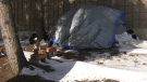
'Enough is enough': Doug Ford says Ontario could hand encampment drug users $10,000 fines, prison
Ontario Premier Doug Ford says his government is introducing a suite of measures to help municipalities “address and dismantle” homeless encampments around the province, including steep fines for people who use drugs.
-
Marathon budget meeting ends without setting Waterloo Region budget
Waterloo Region Council was expected to set the 2025 budget on Wednesday, but after a marathon meeting, councillors left the horseshoe without making a final decision.
-
Settlement reached in complaint over Canada Post layoffs as strike hits four weeks
The union representing Canada Post workers says an unfair labour practice complaint over the company's layoffs has been resolved.
Barrie
-

Significant weather event declared in Owen Sound amid blizzard warning
The City of Owen Sound has declared a significant weather event with the region under a blizzard warning on Thursday as lake-effect snow squalls hammer the area.
-
Jack-knifed tractor-trailer in Gravenhurst as squalls continue
A jack-knifed tractor-trailer caused lane closures along Highway 11 near Bethune Drive South in Gravenhurst.
-
Teen arrested in connection to threat made toward high school: OPP
Provincial police arrested a 17-year-old from Bolton accused of making a threat toward a local high school.
Windsor
-

Shots fired in South Windsor, one injured
An investigation is underway after the Windsor Police Service said multiple shots were fired at a group of people in South Windsor.
-
One injured in Windsor kitchen fire
One person has been injured following a kitchen fire in Windsor.
-
Woman charged after throwing pot of coffee in Chatham business: CKPS
Chatham-Kent police charged a woman who allegedly threw a pot of coffee when asked to leave a business in Chatham.
Northern Ontario
-
 BREAKING
BREAKING Northern Ont. bank employee taken to hospital with serious injuries after shooting
An employee at Northern Credit Union in Wawa, Ont., was taken to hospital with serious injuries after a shooter entered the branch and opened fire Thursday morning, the financial institution said in a statement.
-
Stabbing in wooded area of Sudbury results in attempted murder charge
Sudbury police have charged a man, 28, with attempted murder after a stabbing in wooded area off Leslie Street on Wednesday night.
-
Ottawa has sold its stake in Air Canada: sources
Two senior federal government sources have confirmed to CTV News that the federal government has sold its stake in Air Canada.
Sault Ste. Marie
-
BREAKING
BREAKING Northern Ont. bank employee taken to hospital with serious injuries after shooting
An employee at Northern Credit Union in Wawa, Ont., was taken to hospital with serious injuries after a shooter entered the branch and opened fire Thursday morning, the financial institution said in a statement.
-
Snow squall warnings in the Sault Ste. Marie area, up to 50 cm expected by Friday
Snow squall warnings issued for the Sault Ste. Marie area off Lake Superior as 30 to 50 cm of snow is expected by Friday.
-
Ontario man charged with sex trafficking underage girls from Sudbury, Kingston
Two young girls, from Sudbury and Kingston, Ont., were rescued from sex trafficking in the GTA and their suspected abuser has been charged, but police fear there may be more victims.
Ottawa
-

Two additional arrests made in connection with Val-des-Monts death investigation
Police have arrested two additional people in connection with an investigation into a woman's death north of Gatineau earlier this month.
-
Bus parked at OC Transpo depot destroyed by fire
Ottawa firefighters extinguished a bus that was fully engulfed in flames while parked at an OC Transpo depot on Thursday afternoon.
-
Crews begin removing cargo from ship stuck in St. Lawrence River in eastern Ontario
Crews have started work on a new attempt to refloat a cargo ship that ran aground in the St. Lawrence River nearly three weeks ago.
Toronto
-
'Enough is enough': Doug Ford says Ontario could hand encampment drug users $10,000 fines, prison
Ontario Premier Doug Ford says his government is introducing a suite of measures to help municipalities “address and dismantle” homeless encampments around the province, including steep fines for people who use drugs.
-
Video shows suspects armed with sledgehammer break into spa in Markham
Three teenagers and a 19-year-old man have been arrested and three more are at large in connection with a series of spa robberies in Markham and Toronto, one of which was captured on security camera.
-
Dog found after vehicle stolen in Toronto
A dog that was inside a vehicle when it was stolen in Toronto on Wednesday has been found, police say.
Montreal
-

Montreal homicide rate dropped by more than 20 per cent in 2023: Statistics Canada
Newly released figures from Statistics Canada shows that the rate of homicides in the Montreal area dropped significantly in 2023 compared to the previous year.
-
Quebec to pay 30 times more for power out of N.L. plant after decades-long dispute
Quebec and Newfoundland announced today a new arrangement that will see Quebec pay 30 times more for power from the Churchill Falls hydroelectricity plant in Labrador.
-
Montreal suburb declares 'end of deer saga' after killing 105 animals in urban park
A Montreal suburb is declaring the 'end of the deer saga' today after completing its plan to cull a growing herd of white-tailed deer in one of its parks.
Atlantic
-

Bass River, N.S., bridge partially collapses
A bridge in Bass River, N.S., partially collapsed on Wednesday. The wooden structure was under construction when one side gave way and fell into the river.
-
N.S. Premier Tim Houston reveals new cabinet, department names
The new cabinet for the Nova Scotia government will have its swearing-in ceremony Thursday afternoon.
-
Deal between Ottawa and N.S. First Nation over contested fishery nearly done: lawyer
The lawyer for a Mi'kmaq band that has battled Ottawa over its lobster harvest rights says a deal settling the "centuries-old" fishing dispute is nearly complete.
Winnipeg
-

'Concerning:' Manitoba homicides spiked in 2024
Manitoba RCMP has seen a spike in homicides in 2024.
-
New hammer rule to be tested at next Grand Slam of Curling event
As far as curling experiments go, a new rule that will be used at the next Grand Slam competition looks like a doozy.
-
Colleen Bready's Forecast: How long will the extreme cold last?
Extreme cold continues to hold its grip on much of Manitoba and northwestern Ontario on Thursday.
Calgary
-

Calgary police to hold news conference following young woman's death
Calgary police will hold a news conference Thursday to speak about the death of a young woman found badly injured on Calgary's Nose Creek Pathway on Monday.
-
Danielle Smith approval rating holds steady at 45%: poll
A new poll from the non-profit Angus Reid Institute finds that Alberta Danielle Smith’s approval rating once again remains relatively unchanged.
-
Man who set fires inside Calgary's municipal building lost testicle during arrest: ASIRT
Two Calgary police officers have been cleared of any wrongdoing in an incident that saw a suspect lose a testicle after being shot with an anti-riot weapon.
Edmonton
-
 BREAKING
BREAKING Travis Vader, killer of Lyle and Marie McCann, denied day parole
The man who killed an Alberta couple in 2010 has been denied day parole.
-
BREAKING
BREAKING Edmonton police chief to assume leadership roles in Alberta public service, executive council
Dale McFee will start a job in the high level of Alberta's government three days after his last day as the chief of Edmonton Police Service in February.
-
Former Alberta premier Rachel Notley quitting legislature seat as of Dec. 30
Former Alberta premier and NDP Leader Rachel Notley is leaving the legislature.
Regina
-

Sask. premier says collaboration needed to tackle border security and avoid Trump tariffs
Saskatchewan Premier Scott Moe says an “all hands-on-deck approach” is needed to address border security concerns to avoid U.S. President-elect Donald Trump's tariff threat on products from Canada and Mexico.
-
Three charged after Regina police officer assaulted during break and enter investigation
Three people are facing a lengthy list of charges after a break and enter investigation led to a Regina police officer being assaulted and injured Tuesday night.
-
Regina General Hospital parkade set to open, will provide 686 more parking spots
The grand opening of a new parkade at Regina's General Hospital was celebrated on Thursday. Staff and visitors to the medical centre will be able to use the new facility on Monday.
Saskatoon
-
Nearly 1,500 people in Saskatoon are homeless, according to the latest count
Nearly 1,500 people in Saskatoon are homeless, according to the latest point-in-time (PiT) Count conducted by the city and outside partners.
-
Prince Albert police release photo of suspect in family/grandparent scam
The Prince Albert Police Service (PAPS) is releasing a photo of a person of interest in connection with a family/grandparent emergency scam following multiple reports.
-
Sask. premier says collaboration needed to tackle border security and avoid Trump tariffs
Saskatchewan Premier Scott Moe says an “all hands-on-deck approach” is needed to address border security concerns to avoid U.S. President-elect Donald Trump's tariff threat on products from Canada and Mexico.
Vancouver
-

Crews search for missing skier at B.C. resort
Police and rescue crews are searching for a man who was last seen boarding a ski lift at B.C.'s Sun Peaks Resort Tuesday.
-
Man charged after victim pinned to tree with vehicle in Victoria
A 34-year-old man is facing multiple criminal charges after allegedly striking a man with his vehicle and pinning him against a tree in Victoria, causing serious injuries.
-
Star centre J.T. Miller set to return to Vancouver Canucks lineup against Panthers
Star centre J.T. Miller will return to the Canucks’ lineup on Thursday when Vancouver hosts the Florida Panthers.
Vancouver Island
-

Man charged after victim pinned to tree with vehicle in Victoria
A 34-year-old man is facing multiple criminal charges after allegedly striking a man with his vehicle and pinning him against a tree in Victoria, causing serious injuries.
-
Police say 42 vehicles vandalized in 'campaign of destruction' in Nanaimo, B.C.
Mounties are investigating after more than 40 vehicles were vandalized in what police described as a "campaign of destruction" across Nanaimo, B.C.
-
Crews search for missing skier at B.C. resort
Police and rescue crews are searching for a man who was last seen boarding a ski lift at B.C.'s Sun Peaks Resort Tuesday.


