Heat warning expected to come down late Friday
A heat warning remains in effect for parts of the region to kick off July.
Environment Canada has issued the warning for Windsor-Essex, Chatham-Kent, Sarnia-Lambton, Elgin County and London-Middlesex.
Maximum temperatures are expected to reach near 31 C again Friday after a very warm night on Thursday.
Humidex values are expected to be in the mid-30s today.
The heat event is forecast to come to an end tonight.
Friday: Sunny. Increasing cloudiness this morning then 60 per cent chance of showers this afternoon. Risk of a thunderstorm this afternoon. High 30. Humidex 34. UV index 8 or very high.
Friday Night: Mainly cloudy. 60 per cent chance of showers this evening with risk of a thunderstorm. Clearing before morning. Low 14.
Saturday: Sunny early in the morning then a mix of sun and cloud with 30 per cent chance of showers late in the afternoon. High 29. Humidex 31.
Sunday: Sunny. High 26.
Monday: Sunny. High 27.
Tuesday: A mix of sun and cloud with 40 per cent chance of showers. High 25.
Wednesday: A mix of sun and cloud. High 25.
Thursday: A mix of sun and cloud. High 26.


CTVNews.ca Top Stories

DEVELOPING
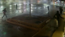
DEVELOPING Person on fire outside Trump's hush money trial rushed away on a stretcher
A person who was on fire in a park outside the New York courthouse where Donald Trump’s hush money trial is taking place has been rushed away on a stretcher.
Mandisa, Grammy award-winning 'American Idol' alum, dead at 47
Soulful gospel artist Mandisa, a Grammy-winning singer who got her start as a contestant on 'American Idol' in 2006, has died, according to a statement on her verified social media. She was 47.
She set out to find a husband in a year. Then she matched with a guy on a dating app on the other side of the world
Scottish comedian Samantha Hannah was working on a comedy show about finding a husband when Toby Hunter came into her life. What happened next surprised them both.
Senators reject field trip to African Lion Safari amid elephant bill study
The Senate legal affairs committee has rejected a motion calling for members to take a $50,000 field trip to the African Lion Safari in southern Ontario to see the zoo's elephant exhibit.
'It could be catastrophic': Woman says natural supplement contained hidden painkiller drug
A Manitoba woman thought she found a miracle natural supplement, but said a hidden ingredient wreaked havoc on her health.
Police in Paris detain a man wearing fake explosives vest at Iran's Consulate
A man wearing a fake explosive vest and making threats was detained Friday outside the Iranian Consulate in Paris after police locked down the area, authorities said. His motive was unclear.
DEVELOPING
DEVELOPING G7 warns of new sanctions against Iran as world reacts to apparent Israeli drone attack
Group of Seven foreign ministers warned of new sanctions against Iran on Friday for its drone and missile attack on Israel, and urged both sides to avoid an escalation of the conflict.
CFIA monitoring for avian flu in Canadian dairy cattle after U.S. discoveries
The Canadian Food Inspection Agency is encouraging veterinarians to keep an eye out for signs of avian influenza in dairy cattle following recent discoveries of cases of the disease in U.S. cow herds.
After hearing thousands of last words, this hospital chaplain has advice for the living
Hospital chaplain J.S. Park opens up about death, grief and hearing thousands of last words, and shares his advice for the living.
Shopping Trends
The Shopping Trends team is independent of the journalists at CTV News. We may earn a commission when you use our links to shop. Read about us.