Flooded streets and basements as more heavy rain causes grief, severe thunderstorm watch in effect
Heavy rain walloped parts of the region again Tuesday, just as many were cleaning up from Monday’s downpour.
In Ilderton, some streets in new developments were submerged during the morning rain. By afternoon, the streets had dried out and a muddy mess was left behind.
Many backyards were also submerged.
“It was pretty wild,” said Bowman Street resident Wayne Langstaff.
“It flooded about three to four feet deep at the low spot in the road here. It didn’t seem like any worse of a rain than we got yesterday or last Wednesday, but because so much in the last little while. It was garbage day so the garbage cans actually flipped and were plugging the drains,” said Langstaff.
To the north and west of London, ditches and fields have been overflowing.
 Jeff Balicki is seen cleaning water from his home on Jalna Boulevard on July 16, 2024. (Bryan Bicknell/CTV News London)
According to the Upper Thames River Conservation Authority, some areas along the watershed have received up to 170 millimeters of rain just in the last week. The ground is saturated and it cannot absorb the runoff.
In south London, Jalna Boulevard resident Jeff Balicki has spent the last couple of days bailing out his basement. His home was flooded for the third time in three years. He had even installed a check valve in the basement to stop the flow of water, but it was to no avail against the intense downpour.
Balicki estimates about $20,000 in losses between damage and contents. He said many of his neighbours are in the same boat.
“What happens is, when we have heavy rain storms in south London the storm sewers back up into the septic sewers. That backs up into our houses all along Jalna Boulevard. At least 15 houses either direction,” said Balicki.
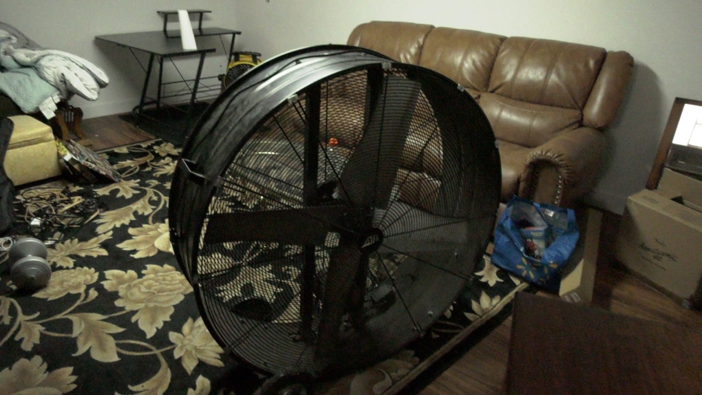
 A fan is pictured in the basement of Jeff Balicki’s home on Jalna Boulevard on July 16, 2024. (Bryan Bicknell/CTV News London)
Civil and environmental engineer Slobodan Simonovic, a professor emeritus at Western University, said municipal infrastructure has been designed based on historical events, and it is not keeping up with climate change.
“The pressures on the urban environment are high, and the demand, the number of people who are coming in, and the developments that go on. We cannot keep up with improving the infrastructure to handle this additional pressure,” he explained.
In the meantime, the city of London says it has received a high number of calls for help with basement flooding. Services have been delayed and crews will respond as soon as possible.
PHOTO GALLERY: July flooding in London
Meanwhile, Environment Canada has issued a severe thunderstorm watch.
Conditions are favourable for the development of severe thunderstorms that may be capable of producing strong wind gusts and heavy rain.
The Upper Thames River Conservation Authority is reminding parents and guardians to keep children and pets away from streams, rivers, and ditches and out of any flooded areas.
Watercourses are fast-moving and high from all the rain, and streambanks are soft and slippery.
Here's a look at the rest of the forecast
Tuesday: Showers ending near noon then mainly cloudy with 40 per cent chance of showers. Risk of a thunderstorm this afternoon. Wind southwest 20 km/h. High 29. Humidex 39. UV index 10 or very high.
Tuesday Night: Mainly cloudy. 40 per cent chance of showers this evening with risk of a thunderstorm. Wind becoming west 20 km/h late this evening. Low 17.
Wednesday: Mainly cloudy. 40 per cent chance of showers in the afternoon with risk of a thunderstorm. Wind becoming northwest 30 km/h gusting to 50 late in the morning. High 25. Humidex 30. UV index 7 or high.
Thursday: Sunny. High 22.
Friday: Sunny. High 25.
Saturday: Sunny. High 27.
Sunday: A mix of sun and cloud with 30 per cent chance of showers. High 26.
CTVNews.ca Top Stories

Trump threatens to try to take back the Panama Canal. Panama's president balks at the suggestion
Donald Trump suggested Sunday that his new administration could try to regain control of the Panama Canal that the United States “foolishly” ceded to its Central American ally, contending that shippers are charged “ridiculous” fees to pass through the vital transportation channel linking the Atlantic and Pacific Oceans.
Man handed 5th distracted driving charge for using cell phone on Hwy. 417 in Ottawa
An Ottawa driver was charged for using a cell phone behind the wheel on Sunday, the fifth time he has faced distracted driving charges.
Wrongfully convicted N.B. man has mixed feelings since exoneration
Robert Mailman, 76, was exonerated on Jan. 4 of a 1983 murder for which he and his friend Walter Gillespie served lengthy prison terms.
Can the Governor General do what Pierre Poilievre is asking? This expert says no
A historically difficult week for Prime Minister Justin Trudeau and his Liberal government ended with a renewed push from Conservative Leader Pierre Poilievre to topple this government – this time in the form a letter to the Governor General.
opinion Christmas movies for people who don't like Christmas movies
The holidays can bring up a whole gamut of emotions, not just love and goodwill. So CTV film critic Richard Crouse offers up a list of Christmas movies for people who might not enjoy traditional Christmas movies.
More than 7,000 Jeep SUVs recalled in Canada over camera display concern
A software issue potentially affecting the rearview camera display in select Jeep Wagoneer and Grand Cherokee models has prompted a recall of more than 7,000 vehicles.
'I'm still thinking pinch me': lost puppy reunited with family after five years
After almost five years of searching and never giving up hope, the Tuffin family received the best Christmas gift they could have hoped for: being reunited with their long-lost puppy.
10 hospitalized after carbon monoxide poisoning in Ottawa's east end
The Ottawa Police Service says ten people were taken to hospital, with one of them in life-threatening condition, after being exposed to carbon monoxide in the neighbourhood of Vanier on Sunday morning.
New York City police apprehend suspect in the death of a woman found on fire in a subway car
New York City police announced Sunday they have in custody a “person of interest” in the early morning death of a woman who they believe may have fallen asleep on a stationary subway train before being intentionally lit on fire by a man she didn't know.


